3D BIM models for heritage asset management
Moving beyond the field of data capture for digital preservation
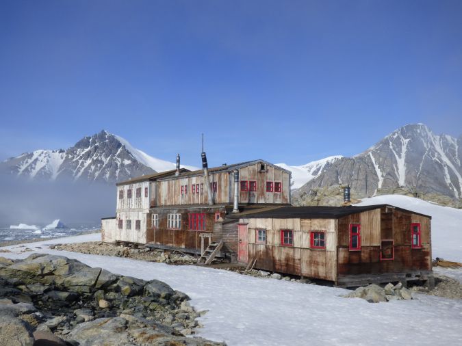
Research undertaken under a collaborative doctoral partnership between Historic England and the University of Reading, UK, is moving beyond the field of 3D data capture for digital preservation. It considers how critical information for the conservation, repair and maintenance of historic buildings can be visualized in 3D BIM models and how BIM processes can be used for the management of structured datasets that inform conservation and repair programmes. A pilot study has been conducted using the work of the UK Antarctic Heritage Trust and historic British research base ‘E’ on Stonington Island, Antarctica, to consider this potential.
Building information modelling (BIM) is a process of information production, management and delivery among project stakeholders. It facilitates collaborative working practices through defined processes and technology, and offers the potential for improved performance and efficiencies and, thus, huge benefits to the construction industry. In view of the government agenda to meet BIM level 2 compliance and the increasing use of BIM in design and construction, the use of BIM technology with existing and historic buildings has been researched for the past decade. It clearly offers benefits for conservation management.
BIM application in the heritage sector
To date, BIM application in the heritage sector has had a heavy focus on digital documentation of heritage assets, fuelled by technological developments in 3D data capture such as photogrammetry and laser scanning. There are numerous examples of heritage assets being documented in this way, and the range of benefits in visualization, structural and condition monitoring, education and research for conservation practice are becoming well understood. Research has considered the practical issues of data capture, subsequent 3D parametric modelling from point cloud data, automated data processing, pattern recognition and the creation of object libraries.
However, an important aspect of recent research that deserves further exploration is the potential of BIM as a centralized data hub, facilitating the production, integration and management of required building information such as survey data, material, constructional and performance analysis, drawings, photographs, historical information and archival data. When data and information is produced or collated in relation to a project or asset, it can build up rapidly. Traditional methods to produce paper-based files or digital PDF documents can be difficult to manage and can get misplaced or missed by individual project stakeholders. Furthermore, information and documentation in this format does not facilitate efficient analysis, planning and decision-making. Key BIM concepts such as component-based parametric modelling and associated data parameters, inventory and database development and the extraction and transfer of structured data to asset information models (AIM), allow for the development of a comprehensive knowledge base. This could be extremely beneficial in the operational phase of a building’s lifecycle, particularly for repair and maintenance.
An Antarctic case study
Established in 1993, the UK Antarctic Heritage Trust (UKAHT) is tasked with the almost impossible mission of preserving the remains of over 70 years of British scientific exploration and research on the Antarctic Peninsula. Faced with the hostile conditions of the Antarctic climate such as katabatic winds, freezing temperatures and sea ice, even getting the necessary equipment (amounting to more than five tonnes) to the remote bases is an accomplishment. In the face of such adversities, UKAHT has taken on the challenge of managing six historic sites and monuments and embarked on a comprehensive survey, conservation and maintenance programme of the buildings and artefacts.
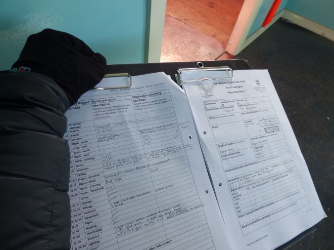
UKAHT’s portfolio had been managed prior to this with what can be best described as ad hoc maintenance work. Basic historic reports were used as guiding documents for conservation decisions and repair philosophy, and conservation work was recorded in annual worklists and end-of-season reports. However, with the appointment of a new CEO in 2014, it was decided that a more informed and managed approach to the conservation of the sites within the portfolio, and the way the trust executed its responsibilities, must be established. Most importantly was UKAHT’s ambition to collate a comprehensive set of base data about the historic sites, including measured survey, condition survey, material sampling, digital recording and artefact audits. Central to achieving these aims would be the development of a new digital data management system.
The pilot study considers the BIM concept of component-based parametric modelling and the application of data parameters to produce structured datasets for heritage asset management. The addition of bespoke ‘conservation’ data parameters, such as element condition, significance and urgency of repair/maintenance, can be used as a visual planning tool within the model and is particularly useful for analysing and interrogating data for the planning of conservation/repair programmes. Furthermore, this data can be extracted in a structured format to be added to the digital AIM and imported into existing property management systems, offering a single source of validated data to support asset management activities.
3D data capture and modelling
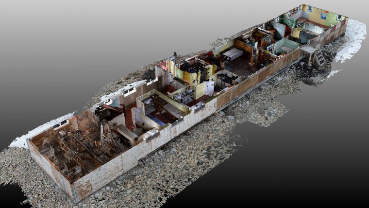
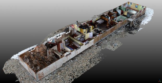
An assessment of logistical difficulties, freezing temperatures and unpredictable weather conditions preceded the decision to use photogrammetry to capture 3D data of the historic huts on the Antarctic Peninsula. A three-week period, an ingenious homemade telescopic pole and the use of coloured tape and food cans as survey points was the sum total required to complete the data capture. Agisoft Photoscan was used to process the digital images and generate 3D spatial data in the form of a point cloud. SketchUp was used to create the initial 3D model from the point cloud. 3D data capture and modelling were arguably the most straightforward steps in the overall process.
The process of adding data parameters to a BIM model of an existing building required more thought. With a view to adding component data retrospectively, it was first important to consider the critical information requirements for heritage asset management and, thus, a framework of ‘conservation’ data parameters. Arranging data in a component-structured asset data capture spreadsheet (similar to a COBie information and data exchange template) was the next important task. The project team decided to break the built assets down into building components and use Uniclass 2015 to classify and structure the data. The ‘asset data capture spreadsheet’ was then developed which would act as the overall ‘database’ in which data from visual condition surveys (conservation data parameters) and the supporting reports would be entered against the building components.
Challenges and surprises
During the Stonington Island field season, a number of challenges and surprises were encountered associated with the introduction of new processes and data capture objectives. The first surprise was the researchers’ focus on the 3D data capture and modelling aspects of BIM as opposed to the potential of BIM as a way of structuring and managing building data. This highlights the need for education in BIM as an information management tool and has contributed to the development of the new Historic England guidance document – Heritage BIM: Developing an Asset Information Model. This document will assist other heritage industry professionals consider their future digital asset management strategies.
Secondly, field seasons in Antarctica are relatively short given the extreme weather conditions and, as such, time is precious. All individuals have a role to play and tasks to complete. The conservation carpenter’s energy was spent carrying out urgent repairs whilst the weather was good, leaving little time for survey and data capture. In terms of a BIM information management process, this challenge identifies the need to determine roles and responsibilities and highlights the importance of the information manager.
Finally, the impact that inanimate objects such as jerry cans can have on a BIM process was both surprising and critical (two days into the crossing of Drake’s Passage, the realization dawned that the team’s fuel supply was missing). This, along with the effect the cold temperature has on laptop batteries and the impact of incompatibility between different laptops and hard drives, illustrates an actor-network effect that must be considered for future research that considers BIM implementation.
Outputs and next steps
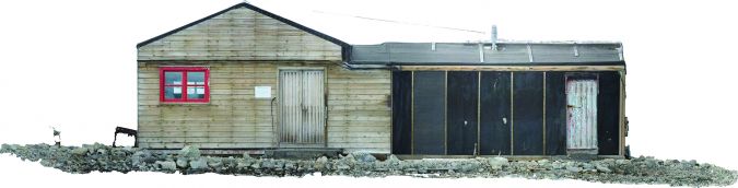
The pilot study has a number of extremely useful outputs. Base E, Stonington Island has now been digitally documented to benefit future generations. 3D data capture allows for a number of further outputs such as 3D virtual tours of the site, thus enhancing public awareness. Moreover, highly accurate CAD drawings, 3D models and orthographic projections have been developed that can be used for the planning of conservation, repair and maintenance, and for the pre-fabrication of replacement building components such as window shutters.
The study has contributed to the development of framework ‘conservation’ data parameters for use by heritage organizations when developing BIM models and where there is an intent to manage condition survey data and asset management within a BIM environment. Future research will look to add developed ‘conservation’ data parameters to a parametric model and consider the benefits of using this visual method for the planning of future conservation/repair.
--------------------
Acknowledgements
Thank you to the UK Antarctic Heritage Trust which has supported this pilot study along with the British Antarctic Survey, Mapping and Geographic Information Centre (MAGIC) for providing expert advice and assistance in digital data capture and processing. Last but not least, thanks to Historic England and the University of Reading for supervising the Collaborative Doctoral Award.
Value staying current with geomatics?
Stay on the map with our expertly curated newsletters.
We provide educational insights, industry updates, and inspiring stories to help you learn, grow, and reach your full potential in your field. Don't miss out - subscribe today and ensure you're always informed, educated, and inspired.
Choose your newsletter(s)


