Mapping the mood of the geospatial community
Insights from our annual industry survey
Despite some uncertainty, there is renewed interest in drones, and remote sensing technologies are being embraced by smaller survey companies. Read these and other findings from our annual industry survey!
The GIM International annual industry survey is about ‘taking the temperature’ of the geospatial industry once a year and exploring the prevailing attitudes among land surveyors around the world. Notable findings this year include renewed interest in drones, remote sensing technologies being embraced by smaller survey companies, concerns about the growth of new geoprofessionals, and uncertainty about the economic and geopolitical situation. Needless to say, we gauged our readers’ opinions on AI: what do they expect from artificial intelligence, and how can it evolve from a buzzword to practical applications? Read on for your peers’ insights into these and many other topics!
These times of technological innovations, social developments, ecological crises and economic uncertainties create challenging circumstances for companies across various sectors and regions. Additionally, the geopolitical situation is far from stable; in 2024, more than half of the world’s population will be voting in a national election. Meanwhile, the extreme effects of climate change are becoming increasingly visible and concerns are growing about whether the world can work together adequately to tackle this major issue. Moreover, a recent report from the Capgemini Research Institute shows that global supply chains are currently threatened by a host of factors, including inflation, geopolitical tensions and conflicts, rising global overpopulation and migration, over-reliance on certain countries for parts, fluctuating freight rates and port congestion. It is not only that this backdrop forms the context for the activities within the mapping and surveying sector. More importantly, members of the geospatial industry are aware of their critical role in helping society to face all these issues together.
Reasons for concern
So how are all the abovementioned factors shaping the dynamics in our specific sector? Let’s just say, the mood has been better. The individual elements impact on different geospatial professionals in different ways, but they are definitely leaving a mark on daily business operations and defining the atmosphere in the industry.
Skilled personnel
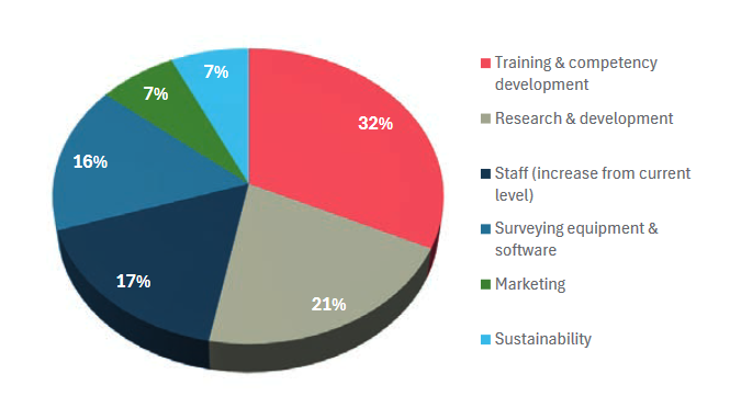
Finding skilled personnel remains a significant challenge in today’s geospatial industry. This challenge has persisted for several years, leading to a shortage of skilled surveying engineers and a general lack of basic knowledge among professionals. Consequently, organizations have smaller teams, making it difficult to deliver relevant knowledge and skills, or to build internal processes and attract new leads through marketing efforts. Our survey shows that more and more companies appear to be getting caught up in this vicious circle.
Now that the long-awaited democratization of geospatial technology is increasingly taking shape, the struggle to recruit competent new employees to strengthen one’s company or organization is becoming even more apparent – especially in certain parts of the world. One survey participant summarizes it as follows: “Too many non-qualified people are getting their hands on GPS, drones and scanners for survey location and topography without knowledge of survey practices. The surveyors know and use cross-checking, ground-truthing and verification-redundant measurements to certify accuracy. Other non-trained surveyors are capturing data that looks like survey data and is being used without any professional checks. This is going to produce a lot of junk information that will be used.” Another response sums up the situation of many: “Our growth ambitions are being hindered by the low student enrollment in engineering.”
Keeping up with technology
The pace of innovation in the field of geospatial data collection in recent years has been impressively fast-paced. Consider for example the dramatic evolution in reality capture, which once used to be based on a handful of points and dimensions. Now, the domain of possibility extends to generating highly precise 3D point clouds, revolutionizing our perception of spatial data capture. It is sometimes overwhelming to see how realistic the data is that comes from the latest 3D laser scanners and mobile mapping equipment. Yet advanced technology is not necessarily a blessing for everyone. This year’s survey shows that keeping up with technological changes can be quite a challenge, especially for smaller companies that provide surveying services. As one respondent describes it: “[…] that is perhaps because of the speed surveying technology develops. If you want to be up to date on the latest features, this is a costly affair. Also training to invest in personnel to stay up to date.” Another participant comments: “The changing technology has impacted the usual approach to work. Over the years, this has been met by recruiting new graduates and briefly training staff members to adapt and be able to be present with the changing technology trend.”
Geopolitics
When it comes to the geopolitical landscape, the number of comments that were submitted by survey participants speaks for itself. Running a business in 2024 is impacted by the ongoing war in Ukraine and various other conflicts across the world, the fear of a global recession, and geopolitical instability. Additionally, some businesses, particularly in the Lidar and electronics sectors, are struggling with supply chain disruptions due to global political tensions. Moreover, entrepreneurs worry about the potential escalation of economic challenges, including inflation.
Reasons for optimism
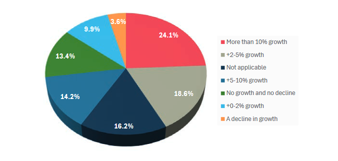
Despite these concerns, the majority of survey respondents mainly see opportunities and are positive about the business outlook. There are a number of underlying factors for this, including the fact that challenges or threats – such as the need for a sustainable transition – can sometimes also bring opportunities.
Construction and infrastructure boom
There is an unprecedented boom in infrastructure and construction projects. This is creating a strong demand for accurate and reliable geoinformation. Moreover, the construction and infrastructure sectors are undergoing a digital revolution. Traditional tools and processes are being replaced by digital workflows. Technological innovations improve the way projects are executed. Here, too, the land surveyor plays a major role.
The anticipated growth opportunities are clearly reflected in the responses from our survey participants. One respondent emphasizes the increasing workload driven by infrastructure projects and technological advancements. This is echoed by another respondent, who points to the growing adoption of digital twins for inspection purposes as a catalyst for market expansion.
Another survey participant highlights their company’s current boom, attributing it to the thriving construction industry and increased resource exploration activities. This trend is not unique to a specific region, as noted by a geospatial engineering professional from Saudi Arabia, who underscores the significant growth in projects across the country. This surge in projects has resulted in “a substantial demand for skilled personnel and modern survey equipment to support the expanding project portfolio.” Similarly, in August 2023, Singapore’s The Strait Times wrote: “By 2025, the government of India aims to add 38,650km of highways to the current 161,350km, build 400 semi-highspeed trains and 220 new airports, and double port capacity to 3,000 million tonnes per annum.” This will create huge demands for geospatial expertise.
Sustainability as an opportunity
Mapping and surveying technologies undoubtedly play a crucial role in supporting successful and sustainable operations by facilitating infrastructure planning and development. After all, it is impossible to develop large offshore or land-based wind farms or construct and maintain mega solar parks without geospatial data. This is illustrated by one respondent who mentions the strategic utilization of geomatics to bolster planning efficiency and productivity amidst climate change challenges. And the boom is not limited to Western nations. Countries such as China and India must also ensure that their economic growth occurs in a sustainable manner.
Additionally, trends such as the energy transition and ongoing digital transformation require so-called rare earth metals for use in wind turbines, electric cars, electronic devices and much more. This too is creating opportunities for industry players, as highlighted by comments such as: “The need for rare earth materials is driving the increase in demand for multispectral data, resulting in more work for our company,” and “For our company, satellite imagery and analysis presents a large growth area. The geospatial industry has risen to the challenging issues ravaging the world, and imaging and analysis has come a long way to assist in this regard.”
In the survey, environmental and climate-related surveys based on remote sensing are also cited multiple times as a significant market. One respondent shares the following view on climate change: “The planet is in a crisis and each country has its own challenges to address. Surveying is in the critical path of all big projects that either negatively or positively impact climate. Climate finance is readily available.”
Tools to get the job done
The impressive technological evolution that has been underway in the geospatial industry since the turn of the century has resulted in today’s wide choice of tools – hardware and software solutions, often presented as an entire workflow – to help surveyors get the job done. All these advanced survey instruments and methods are opening up a multitude of new opportunities: “The advancement of new and efficient tools based on remote sensing is leading to the acquisition of new survey projects for us,” states one participant. Other responses echo this: “Due to new survey instruments, we can accept more projects,” and “The market is growing and we have access to new technologies to anticipate on this.”
Remote sensing
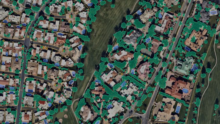
Due to recent technological developments, remote sensing methods have come within reach for a broader group of users, and this year’s GIM International geospatial industry survey reveals a breakthrough regarding the number of smaller surveying companies that seem to be seizing them with both hands. As one of them points out: “Because we now have technology that’s able to easily survey through and around, people are going to capitalize on it.” Another geospatial expert notes: “The integration of scanning and 3D modelling is instrumental in driving the expansion of our company. With the rapid advancements in technology, our capacity to capture and process vast amounts of data will streamline the creation, manipulation and analysis of 3D models, setting a new standard in our industry.”
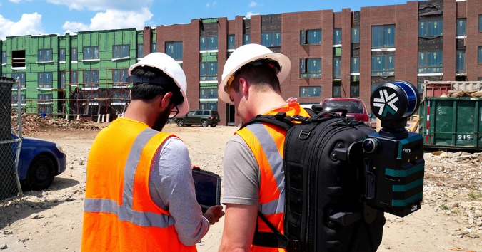
In recent years, hardware manufacturers have launched a whole category of remote sensing equipment at an affordable price. These solutions often provide decent quality and therefore make them suitable for various applications, as one participant points out: “Handheld laser scanners provide rapid and precise 3D scanning capabilities for capturing detailed as-built information.” Handheld laser scanning is indeed one example of the new survey methods that have entered the market, offering flexibility for small survey companies. Utilizing Lidar technology in a portable device, it is an ideal approach for projects prioritizing speed over precision.
Drones
The ‘hype’ around uncrewed aerial vehicles (UAVs or ‘drones’) was at fever pitch around a decade ago. Since then, the drone has progressed beyond the hype and become part of the standard equipment in a surveyor’s toolkit. Yet the high number of drone-related responses in this year’s survey indicate renewed interest in this airborne device. For example, one participant comments: “We are experiencing a strong increase in new contracts as a result of our expanded use of drone surveying.”
So why the resurgence? Certainly, the improved efficiency and precision of drones in combination with today’s payloads mean that sites can be measured swiftly and precisely, even in the case of extensive infrastructure or challenging, inaccessible or hazardous terrain. This can largely be attributed to the growing availability of ever-smaller and affordable yet highly accurate sensors for a larger user group.
Each application area in which a drone is used for mapping and surveying purposes has its own specific needs and requirements. Nowadays, these can be met more and more effectively. When outlining the advantages of incorporating UAVs into their operations, one respondent cites the ability of drones to accelerate mapping procedures and efficiently collect large volumes of data. Meanwhile, another survey company owner reveals plans to invest in UAV technology, particularly to leverage Lidar sensors and high-resolution cameras for data capture. This emphasizes the critical role these tools – in combination with the essential data-processing software – play in fulfilling clients’ geospatial data requirements.
One key development in recent years has been the rise in the number of Lidar-equipped drones entering the market. Such systems empower surveyors to capture highly precise 3D data, rendering them invaluable for a multitude of client projects. Indeed, this is underlined by this year’s survey, with a large number of companies and organizations expressing strong interest in investing in the combination of UAV and Lidar technology.

High-end vs low-end solutions
Optimal survey hardware and software solutions can significantly reduce project costs by facilitating efficient project management. The specific survey requirements should dictate whether a high-end or low-end solution is needed. For example, there is increasing demand for cost-effective and scalable mapping solutions tailored to fit-for-purpose land administration. Similarly, while Lidar solution manufacturers have made significant strides in promoting accuracy as a key feature, achieving millimetre-level precision is not always needed. In many cases, such a level of precision may be excessive for the intended scope of projects.
However, the rise in the availability and affordability of lower-end mapping techniques such as drones – putting them within reach of many non-surveyors – is sparking some discussion, as evidenced by the findings of our industry survey. One respondent urges: “Surveyors and other geospatial professionals should up their game to produce the added value vs some ‘dude’ with a €2k laser scanner.” Another participant comments: “It is true that the growing number of accessible surveying solutions have impact on the surveying profession, but unfortunately to some extent negatively with respect to recruitment of equipment operators with no specific survey training, thus killing the industry.”
Artificial intelligence
Whereas UAVs were on everyone’s lips in the previous decade, it is evident that artificial intelligence (AI) has now emerged as the latest buzzword – and not just in the geospatial industry, of course. So what do members of our community expect from AI in the geospatial sector? “Reducing time and the amount of staff required to do tasks with AI will be a game changer for the industry,” comments one participant, which is representative of many of the responses. Another positive respondent states: “AI can enhance the analysis of geospatial data by automating processes such as image recognition, object detection and pattern identification. This can lead to more accurate and timely insights from satellite imagery, aerial surveys, points clouds and other geospatial data sources, and thus will be a very helpful tool.”
The majority of the geospatial community seem to welcome AI, and some are even deploying it already. However, others are somewhat sceptical and believe that common sense should be applied when considering these developments. “Expectations are high but unrealistic in a practical sense,” believes one participant. Another respondent compares AI to previous hypes: “MOOCs (massive open online courses, Ed.) were gonna kill universities. They didn’t. EDM (Electronic Distance Measurement, Ed.) was gonna kill surveying. It didn’t. GPS would revolutionize surveying. We’re still here.”
Whether our readers are enthusiastic or more hesitant about welcoming AI, there seems to be little concern that geospatial professionals will become redundant. “AI is another tool to help out with some things. But we’ll still need experts to manipulate the tools and take responsibility for decisions,” believes one respondent. “We can’t replace a land surveying professional with AI. The latest surveying instruments must be operated with a human being,” says another. That sentiment is echoed succinctly by a similarly optimistic proclamation: “I still have faith in human intelligence.”
Conclusion
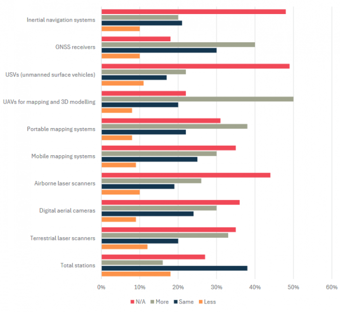
The power of geospatial technology gives governmental bodies and private enterprises alike the opportunity to orchestrate comprehensive infrastructure planning for mass transit, public spaces and ecofriendly development initiatives. This makes it possible to foster the growth of intelligent, resilient communities, ultimately enhancing the overall quality of life while promoting economic prosperity. As illustrated by some of the responses in this year’s GIM International geospatial industry survey, shifts such as the boom in infrastructure and construction, the sustainability trend, the energy transition and the ongoing digital transformation are creating a lot of new and interesting projects for land surveyors and other specialists in our field. In terms of the adoption of new technology, the focus is often on remote sensing technology, with extra emphasis on UAV-Lidar solutions and portable mapping systems.
However, the survey also reveals various concerns about the impact of geopolitical and economic issues on the world in which the industry operates. Moreover, various respondents question how our profession – which is already under pressure – will be able to deal with the growing workload in view of the current shortage of competent staff and the lack of young talent entering the industry. To rise to this challenge, the industry itself will need to take the lead in a strategic and collaborative approach, and remain open-minded to how technological advancements such as AI and automation can help.
Valuable insights
As is customary each year, this edition of the GIM International industry survey once again delivered us a wealth of information, serving as a treasure trove of valuable insights for all stakeholders within the geospatial sector. This article provides a mere peek at the revealing results. Other noteworthy findings include the burgeoning interest in remote sensing solutions and other areas that are perceived as offering the most growth potential. The survey also explored the impact of the expanding array of accessible surveying solutions. For example, how do respondents expect budget-friendly universal RTK GNSS receivers and handheld laser scanners, combined with advanced software, to change the face of the surveying profession? And how will these developments affect the prioritization of investments within industry organizations over the next three years? At GIM International, we will provide you with further insights derived from our industry survey throughout the year.
Value staying current with geomatics?
Stay on the map with our expertly curated newsletters.
We provide educational insights, industry updates, and inspiring stories to help you learn, grow, and reach your full potential in your field. Don't miss out - subscribe today and ensure you're always informed, educated, and inspired.
Choose your newsletter(s)


